Geofencing
Geofencing was a research and innovation program funded by the Swedish Transport Administration. We have gathered actors in society, business and academia and together we have produced material that can help municipalities and regions understand what geofencing is and how the tool can be implemented. The program ended in 2022. On this page, you can therefore take part in the results produced regarding what geofencing is, how it can be used and some other tips and tricks.
What is geofencing?
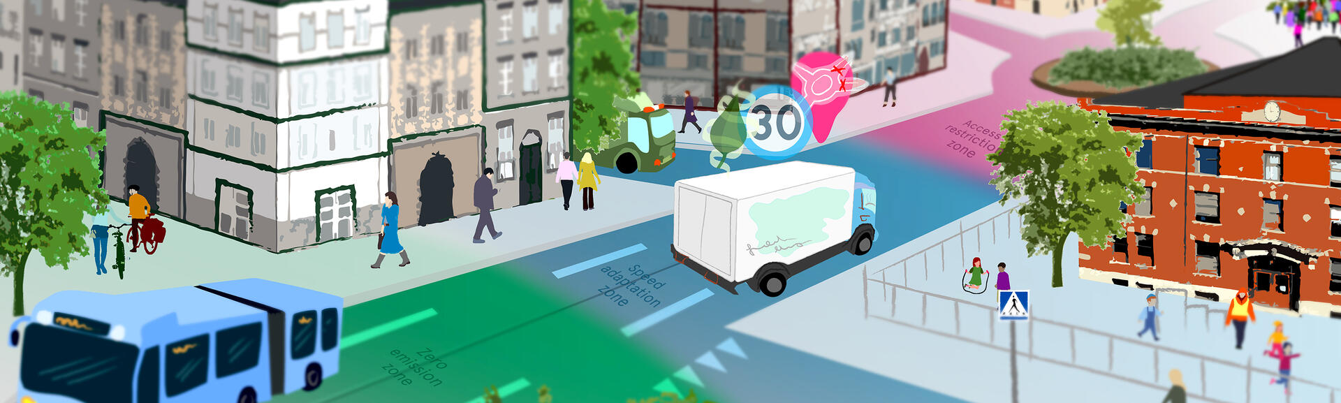
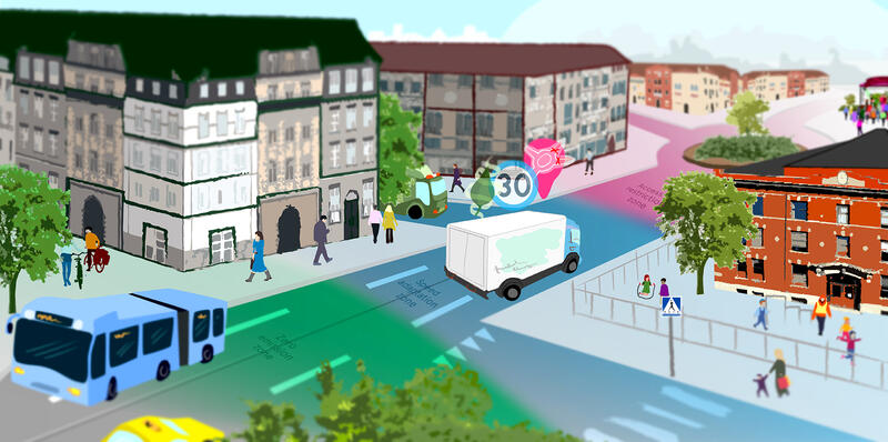
Geofencing (also called Geostaket) is a collective term that includes the application of technical solutions in combination with suitable digital and organizational processes to ensure that vehicles follow certain characteristics within certain geographical areas. Geofencing is considered to be an important tool for creating a safe road transport system for unprotected road users in today's complex traffic environments. It is also considered important to be able to meet both today's and future demand for safe, fossil-free and quieter transport. The research and innovation program for geofencing aims to facilitate and coordinate projects and initiatives that push towards large-scale implementation.
Today, vehicles are largely connected, which can be used to create a sustainable and safe environment. Geofencing defines a digitized geographic zone within which properties of connected vehicles can be controlled, e.g. speed and powertrain. In the long run, geofencing can also be used to restrict access to specific zones or areas. You can read more about geofencing on the Swedish Transport Administration's website (in Swedish).
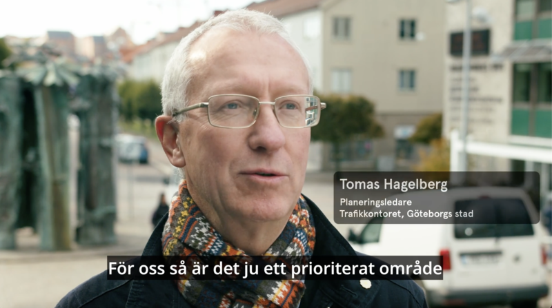
How can your municipality use geofencing to create sustainable traffic environments?
How do we create a geofencing solution?
Below you will find a step-by-step guide from need to implementation. There is also a knowledge guide about Geofencing, it has everything you could possibly need to start an implementation of Geofencing in your municipality or region.
How did geofencing become a reality?
The purpose of the research and innovation program was to act as a facilitator and knowledge node to develop the conditions for the use of geofencing as a tool for a safer and more sustainable transport system. The program aimed to identify areas that require development and where projects need to be initiated to ensure scalability.
What did we achieve with this collaboration?
- Initiated and managed feasibility studies and innovation projects in the field.
- Created a basis for necessary changes in the regulatory framework.
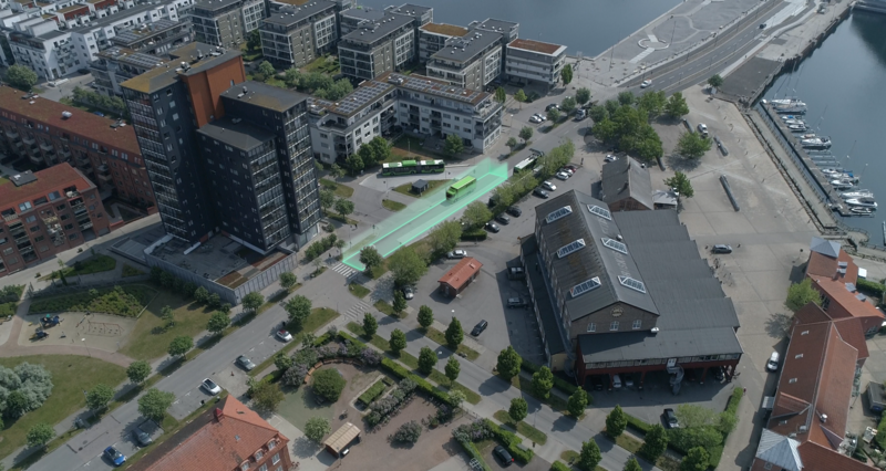
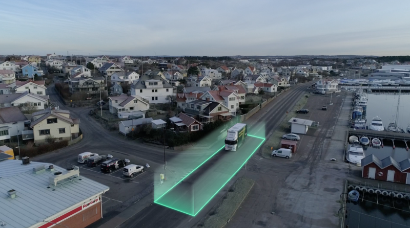
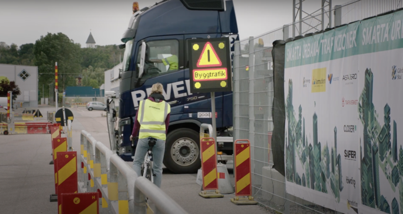
- Conducted geofencing demonstration and pilot studies in designated zones.
- Ensured knowledge exchange between ongoing initiatives and related fields.
- Became a knowledge node and disseminate expertise in the field.
Who are we that worked with Geofencing?
Från vänster: Ted Cruse, CLOSER, Anna-Karin Salmi, Trafikverket, Rodrigue Al Fahel, Caroline Karlsson, Felicia Hökars & Daniel Moback, CLOSER
Do you want to know more about the ongoing Geofencing initiatives?
GeoSence
Smart urban traffic zones
Geofencing news
How do we use the city spaces in the best way?
How can your city use geofencing to create sustainable traffic environments?
Geofencing - for a safe and secure journey
Smart zones for a more sustainable and safe city
Films about geofencing
Here you can find films about geofencing.
Background
2017 the Swedish Transport Administration was commissioned by the government to test geofencing in demonstration projects in urban environments. The work was done in close collaboration with the automotive industry as well as the city of Stockholm and the city of Gothenburg.
The assignment resulted partly in a demonstration of concepts for geofencing, and partly in an overall action plan, which shows the way towards the implementation of the digital tool geofencing on a larger scale.
The action plan is as follows:
- Establish an R&D program with targeted research and innovation projects to produce the necessary basis for the work on all points of the action plan.
- Advocate for legislation and regulations that support the implementation of geofencing
- Develop organizational and digital processes as well as data for geofencing zones
- Develop systems, routines and processes for self-regulating systems and control in smart zones
- Investigate the socio-economic and business potential
- Work for national and international harmonization
- Promote and run demonstration and pilot projects
Facts:
The program ran until 2022, coordinated by CLOSER with participating steering group partners: Scania AB, AB Volvo, Volvo Personvagnar AB, Veoneer AB, Stockholms stad, Göteborgs stad, Transportstyrelsen and Trafikverket.
The consortium is continuously expanded and is a platform for sharing knowledge in geofencing. The FoI-program works closely with the Nordic Way-projects and the Smarta Urbana Trafikzoner project
Want to know more about Geofencing?

Daniel Moback

Rodrigue Al Fahel
Felicia Hökars
Read more
By and with Malin Stoldt, City of Gothenburg and Robin Billsjö, City of Stockholm.
Analysis of the state of knowledge about geofencing and possible business models
This report is the result of a study of the challenges and needs of stakeholders in the transport system which could be met by geofencing services. It describes the problems and requirements of stakeholders from different transport sectors as well as various geofencing applications that are wanted by these stakeholders. The analysis also goes into the challenges regarding the experience and knowledge of geofencing and potential business model structures.